GIS모델링연구실
-
GIS모델링 연구실에서는 지리정보시스템(geographic information system, GIS)을 기반으로 토지피복지도제작, 토지피복분류, 지진취약성지도제작, 해양드론사진측량사진시스템, 산사태 취약성 지도제작 및 교차검증, 지하수 잠재가능성 평가, 공간패턴모델링, 도시성장 예측 등과 관련된 연구를 수행하고 있습니다.
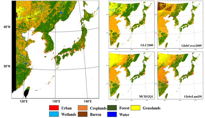
정지궤도위성 기반의 토지피복지도 제작 가능성 평가
- GOCI 자료를 이용하여 세계 최초 동북아시아 토지피복지도 제작 및 가능성 평가
-
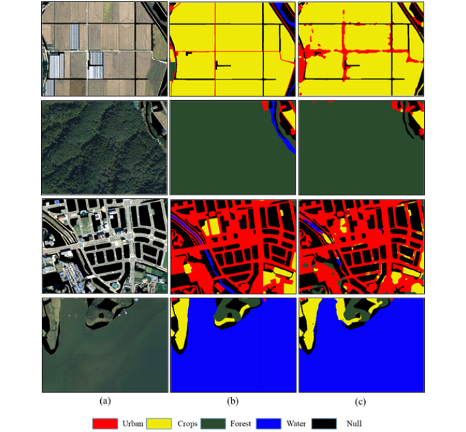
딥러닝 기반의 토지피복분류
- 고해상도 항공영상과 딥러닝 기반의 의미분할(Semantic Segmentation)을 이용하여 토지피복 분류 및 성능 평가

-
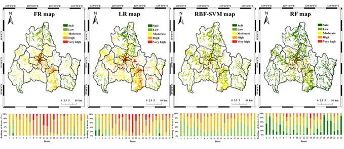
GIS 기반의 지진재해취약성 평가 및 지도제작 연구
- 다양한 방법론(통계, 확률, 기계학습, 딥러닝 등) 및 영향인자를 이용하여 지진취약성(seismic vulnerability) 평가 및 지도제작
-
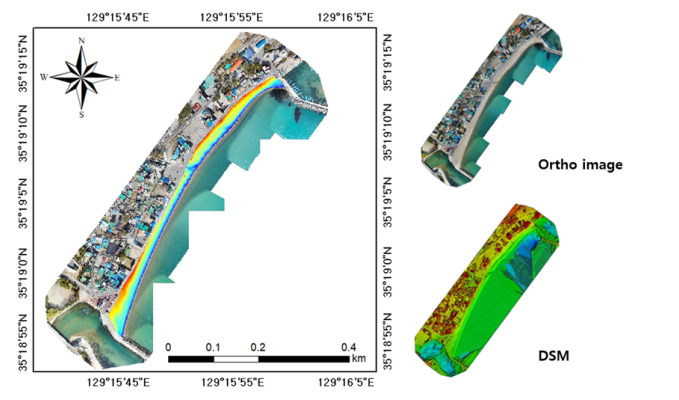
무인항공기 기반의 연안 모니터링
- 무인항공기(unmanned aerial vehicle, UAV)와 지상라이다를 통해 수집된 수치표고모델(digital surface model, DSM)을 비교분석하여 해수욕장의 해빈체적변화 및 기선별 침식변화탐지 및 가능성 평가
-
도시성장 및 토지피복변화 예측
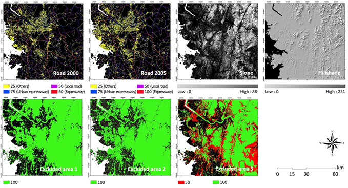
- SLEUTH 모델과 로지스틱 회귀모형을 이용한 도시성장 및 토지피복변화 예측
- 기후변화시나리오에 따른 미래 토지피복변화 예측
- 기후변화시나리오와 통일시나리오에 따른 남, 북한 도시성장 및 농작물 작황 예측
기후변화와 토지피복변화가 미래 수자원에 미치는 영향 평가
GIS 기반 산사태 취약성 평가 지도 제작 및 교차 검증
빅데이터를 이용한 새로운 개념의 공간패턴 모델링
-

손상훈
- 직급
- 박사수료
- ssh3496@naver.com
- 학위
- 부경대학교 지구환경시스템과학부 공간정보시스템공학전공(공학석사)
- 연구주제
- 정지궤도위성기반 토지피복지도 제작가능성평가
-

이도이
- 직급
- 박사수료
- doee2@pukyong.ac.kr
- 학위
- 부경대학교 공간정보시스템공학과(공학사)
- 연구주제
- SAR 영상 기반 수체 탐지
-

배재구
- 직급
- 박사수료
- baejaegu3@gmail.com
- 학위
- 부경대학교 공간정보시스템공학과(공학사)
- 연구주제
- MMS 자료 기반 정밀도로지도 작성
-

박소련
- 직급
- 박사과정
- thfuschlrh@naver.com
- 학위
- 부경대학교 공간정보시스템공학과(공학사)
- 연구주제
- 녹조 탐지 및 모델링
-

이성혁
- 직급
- 박사과정
- tjdgur17@pukyong.ac.kr
- 학위
- 부경대학교 공간정보시스템공학과(공학석사)
- 연구주제
- 원격탐사자료 및 인공지능활용 피복 분류 연구
-

서정민
- 직급
- 석사과정
- 99sjw@naver.com
- 학위
- 부경대학교 공간정보시스템공학과(공학사)
- 연구주제
- MBES 자료 활용 해저면 피복 분류
-

이채안
- 직급
- 석사과정
- j222388@pukyong.ac.kr
- 학위
- 부경대학교 지구환경시스템과학부 위성정보융합공학전공(공학사)
- 연구주제
- Sentinel-2 기반 동계작물 수확량 분석
-
김성헌
- 석사졸업(2020)
- 연구주제: 무인항공기기반 연안모니터링
- 현재소속: 군무원
-
- 한지혜
- 석사졸업(2020)
- 연구주제: 지진재해취약성평가 및 지도제작
- 현재소속: 국립재난안전연구원
-
- 류민지
- 석사졸업(2023)
- 연구주제: 미세먼지 예측 및 취약성분석
- 현재소속: 기상청
논문
-
International Journals
- (33) Multi-Satellite Image Matching and Deep Learning Segmentation for Detection of Daytime Sea Fog Using GK2A AMI and GK2B GOCI-II, Remote Sensing, Kang, J., Miyazaki, H., Kim, S.H., Kafatos, M., Kim, D., Kim, J., Lee, Y., Remote Sensing, 18(1), 34, 2025.
- (32) AI-Based Mapping of Offshore Wind Energy Around the Korean Peninsula Using Sentinel-1 SAR and Numerical Weather Prediction Data, Joh, J.S.-u., Nghiem, S.V., Kafatos, M., Liu, J., Kim, J., Kim, S.H., Lee, Y., Energies, 18(23), 6252, 2025.
- (31) Estimation of Flood Inundation Area Using Soil Moisture Active Passive Fractional Water Data with an LSTM Model, Febrian, R.D., Kim, W., Lee,Y., Kim, J., Choi, M., Sensors, 25(8), 2503, 2025.
- (30) Minimizing Seam Lines in UAV Multispectral Image Mosaics Utilizing Irradiance, Vignette, and BRDF, Ahn, H., Kim, C., Lim, S., Jin, C., Kim, J., Choi, C., Remote Sensing, 17(1), 151, 2025.
- (29) Single-Temporal Sentinel-2 for Analyzing Burned Area Detection Methods: A Study of 14 Cases in Republic of Korea Considering Land Cover, Lee, D., Son, S., Bae, J., Park, S., Seo, J., Seo, D., Lee, Y., Kim, J., Remote Sensing 16(5), 884, 2024.
- (28) Estimation of High-Resolution Soil Moisture in Canadian Croplands Using Deep Neural Network with Sentinel-1 and Sentinel-2 Images, Lee, S., Choi, C., Kim, J., Choi, M., Cho, J., Lee, Y., Remote Sensing, 15(16), 4063, 2023.
- (27) Special Issue on Selected Papers from “International Symposium on Remote Sensing 2021”, Hong, S. H., Kim, J., Jung, H. S., Remote Sensing, 15(12), 2993, 2023.
- (26) Land-Cover-Change Detection with Aerial Orthoimagery Using SegNet-Based Semantic Segmentation in Namyangju City, South Korea, Son, S., Lee, S. H., Bae, J., Ryu, M., Lee, D., Park, S. R., Seo, D., Kim, J., Sustainability, 14(19), 12321, 2022.
- (25) Robust Spatiotemporal Estimation of PM Concentrations Using Boosting-Based Ensemble Models, Park, S., Son, S., Bae, J., Lee, D., Kim, J. J., Kim, J., Sustainability, 13(24), 13782, 2021.
- (24) Effects of Fences and Green Zones on the Air Flow and PM Concentration around a School in a Building-Congested District, Park, S. J., Kang, G., Choi, W., Kim, D. Y., Kim, J., Kim, J. J., Applied Sciences, 11(19), 9216, 2021.
- (23) The Predictive Capability of a Novel Ensemble Tree-Based Algorithm for Assessing Groundwater Potential, Park, S., Kim, J., Sustainability. 13(5), 2459, 2021
- (22) Seismic Vulnerability Assessment and Mapping of Gyeongju, South Korea, using Frequency Ratio, Decision Tree, and Random Forest, Han, J., Park, S., Son, S., Ryu, M., Kim, J., Sustainability, 12(18), 7787, 2020
- (21) Development of Geo-KOMPSAT-2A Algorithm for Sea-Ice Detection Using Himawari-8/AHI Data, Jin, D., Chung, S., Lee, K., Seo, M., Choi, S., Seong, N., Jung, D., Sim S., Kim J., Han, K., Remote sensing, 12(14), 2262, 2020
- (20) Evaluation of NDVI Estimation Considering Atmospheric and BRDF Correction through Himawari-8/AHI, Seong, N. H., Jung, D., Kim, J., Han, K. S., Asia-Pacific Journal of Atmospheric Sciences 1-10, 2020.
- (19) Performance of Logistic Regression and Support Vector Machines for Seismic Vulnerability Assessment and Mapping: A Case Study of the 12 September 2016 ML5.8 Gyeongju Earthquake, South Korea, Han, J., Park, S., Kim, S., Son, S., Lee, S., Kim, J., Sustainability 11(24), 7038, 2019.
- (18) Performance Evaluation of the GIS-Based Data-Mining Techniques Decision Tree, Random Forest, and Rotation Forest for Landslide Susceptibility Modeling, Park, S., Hamm, S. Y., Kim, J., Sustainability 11(20), 5659, 2019.
- (17) Feasibility of UAV Photogrammetry for Coastal Monitoring: A Case Study in Imlang Beach, South Korea, Kim, S., Park, S., Han, J., Son, S., Lee, S., Han, K., Kim, J., and Kim, J., Journal of Coastal Research 90, 386-392, 2019.
- (16) Landslide Susceptibility Mapping Based on Random Forest and Boosted Regression Tree Models, and a Comparison of Their Performance, Park, S., Kim, J., Applied sciences 9(5), 942, 2019.
- (15) Effects of wind fences on the wind environment around Jang Bogo Antarctic Research Station, Wang, J., Kim, J., Choi, W., Mun. D., Kang, J., Kwon. H., Kim, J., Han, K., Advances in Atmospheric Sciences 34(12), 1404-1414, 2017.
- (14) Simulating land use change in Seoul metropolitan area after greenbelt elimination using the SLEUTH model, Park, S.,Clarke, K. C., Choi, C., Kim, J., Journal of sensors 2017, 4012929, 18, 2017.
- (13) Forecasting the Potential Effects of Climatic and Land-Use Changes on Shoreline Variation in Relation to Watershed Sediment Supply and Transport, Kim, J., Choi, J., Choi, C., Hwang, C., Journal of Coastal Research 33(4), 874-888, 2017.
- (12) Evaluation of Logistic Regression and Multivariate Adaptive Regression Spline Models for Groundwater Potential Mapping Using R and GIS, Park, S., Hamm, S. Y., Jeon, H. T., Kim, J., Sustainability 9(7), 1157, 2017.
- (11) Radiometric characterization and validation for the KOMPSAT-3 sensor, Kim, J., Jin, C., Choi, C., Ahn, H., Remote Sensing Letters 6(7), 529-538, 2015.
- (10) Impacts of changes in climate and land use/land cover under IPCC RCP scenarios on streamflow in the Hoeya River Basin, Korea, Kim, J., Choi, J., Choi, C., Park, S., Science of the Total Environment 452-453, 181-195, 2013.
- (9) Feasibility of employing a smartphone as the payload in a photogrammetric UAV system, Kim, J., Lee, S., Ahn, H., Seo, D., Park, S., Choi, C., ISPRS Journal of Photogrammetry and Remote Sensing 79, 1-18, 2013.
- (8) Landslide susceptibility mapping using frequency ratio, analytic hierarchy process, logistic regression, and artificial neural network methods at the Inje area, Korea, Park, S., Choi, C., Kim, B., Kim, J., Environmental Earth Sciences 68, 1443-1464, 2013.
- (7) Development of a Network RTK Positioning and Gravity-Surveying Application with Gravity Correction Using a Smartphone, Kim, J., Lee, Y., Cha, S., Choi, C., Lee, S., Sensors 13, 8879-8894, 2013.
- (6) Evaluating the suitability of the EGM2008 geopotential model for the Korean peninsula using parallel computing on a diskless cluster, Lee, S., Choi, C., Kim, J., \Computers & Geosciences 52, 132-145, 2013.
- (5) Accuracy evaluation of a smartphone-based technology for coastal monitoring, Kim, J., Lee, S., Ahn, Y., Seo, D., Seo, D., Lee, J., Choi, C., Measurement 46, 233-248, 2013.
- (4) Impacts of climate change under IPCC RCP scenarios on streamflow and water quality in the Youngsan Basin, South Korea, Choi, J., Park, S., Yeu, Y., Yoon, H., Choi, C., Kim, J., Disaster Advances 6(12) 134-141, 2013.
- (3) GIS-based landslide susceptibility analyses and cross-validation using a probabilistic model on two test areas in Korea, Kim, J., Choi, C., Park, S., Disaster Advances 6(10), 45-54. 2013.
- (2) Assessment of smartphone-based technology for remote environmental monitoring and its development. Lee, S., Kim, J., Jin, C., Bae, S., Choi, C., Instrumentation Science & Technology 40, 504-529, 2012.
- (1) Absolute radiometric calibration of the KOMPSAT-2 multispectral camera using a reflectance-based method and empirical comparison with IKONOS and QuickBird images, Lee, S., Jin, C., Choi, C., Lim, H., Kim, Y., Kim, J., Journal of Applied Remote Sensing 6, 063594, 1-26, 2012.
-
SCOPUS Journals
- (7) Exploring Spatial Patterns of Theft Crimes Using Geographically Weighted Regression, Yoo, Y., Beak, T., Kim, J., Park, S., Journal of the Korean Society of Surveying, Geodesy, Photogrammetry and Cartography 35(1), 31-39, 2017.
- (6) A Comparative Study of the Frequency Ratio and Evidential Belief Function Models for Landslide Susceptibility Mapping, Yoo, Y., Beak, T., Kim, J., Park, S., Journal of the Korean Society of Surveying, Geodesy, Photogrammetry and Cartography 34(6), 597-607, 2016.
- (5) A Comparative Analysis of Landslide Susceptibility Assessment by Using Global and Spatial Regression Methods in Inje Area, Korea, Park, S., Kim, J., Journal of the Korean Society of Surveying, Geodesy, Photogrammetry and Cartography 33(6), 579-587, 2015.
- (4) Potential effects of urban growth under urban containment policy on streamflow in the Gyungan River Watershed, Korea, Kim, J., Park, S., Journal of the Korean Society of Surveying, Geodesy, Photogrammetry and Cartography 33(3), 163-172, 2015.
- (3) Simulating the impacts of the greenbelt policy reform on sustainable urban growth: The case of Busan Metropolitan area, Kim, J., Park, S., Journal of the Korean Society of Surveying, Geodesy, Photogrammetry and Cartography 33(3), 193-202, 2015.
- (2) A comparative analysis of landslide susceptibility using airborne LiDAR and digital map, Kim, S., Lee, J., Kim, J., Roh, T., Journal of the Korean Society of Surveying, Geodesy, Photogrammetry and Cartography 32(4-1), 281-292, 2014.
- (1) Calibration of hydrographic survey multibeam system using terrestrial laser scanning and TS surveying, Kim, J., Journal of the Korean Society of Surveying, Geodesy, Photogrammetry and Cartography 31(3), 183-191, 2013.
-
Domestic Journals
- (36) Machine Learning-Based Near-Real-Time Monitoring of Wildfire Spread Extent Using GK2A and VIIRS, Doi Lee, Sang-il Kim, Do-Seob Ahn, Seung-Chul Kim, Dongju Seo, Minha Choi, Yangwon Lee, Jinsoo Kim, 41(5), 869-881, 2025.
- (35) Sentinel-2 영상과 딥러닝 기반 변화탐지 SNUNet-CD를 활용한 국내 대형 산불피해지 탐지, 배재구, 손상훈, 이도이, 박소련, 이성혁, 서정민, 김진수, 41(3), 537-550, 2025.
- (34) PlanetScope와 Sentinel-2 위성영상을 활용한 Swin Transformer 기반 산불피해 탐지 성능 개선: 다종 데이터 융합의 효과 분석, 이도이, 손상훈, 배재구, 박소련, 이성혁, 서정민, 김예지, 최민하, 이양원, 김진수, 대한원격탐사학회지, 40(6-1), 991-1004, 2024.
- (33) 머신러닝 기반 위성영상과 수질·수문·기상 인자를 활용한 낙동강의 Chlorophyll-a 농도 추정, 박소련, 손상훈, 배재구, 이도이, 서동주, 김진수, 대한원격탐사학회지 39(5-1) 665-667, 2023.
- (32) HRNet 기반 해양침적쓰레기 수중영상의 의미론적 분할, 김대선, 김진수, 장성웅, 박수호, 공신우, 곽지우, 배재구, 대한원격탐사학회지 38(6-1), 2022
- (31) 앙상블 기반 모델을 이용한 서울시 PM 농도 예측 및 분석, 류민지, 손상훈, 김진수, 대한원격탐사학회지 38(6-1), 1191-1205, 2022.
- (30) 머신러닝 기반 MMS Point Cloud 의미론적 분할, 배재구, 서동주, 김진수, 대한원격탐사학회지 38(5-3), 939-951, 2022.
- (29) HRNet-OCR과 Swin-L 모델을 이용한 조식동물 서식지 수중영상의 의미론적 분할, 김형우, 장선웅, 박수호, 공신우, 곽지우, 김진수, 이 양원, 대한원격탐사학회지 38(5-3), 913-924, 2022.
- (28) UNet 기반 Sentinel-1 SAR 영상을 이용한 수체탐지: 섬진강유역 대상으로, 이도이, 박소련, 서동주, 김진수, 대한원격탐사학회지 38(5-3), 901-912, 2022.
- (27) 원격탐사와 GIS 를 이용한 지구환경재해 관측과 관리 기술 현황 2, 양민준, 김재진, 류종식, 한경수, 김진수, 대한원격탐사학회지 38(5-3), 811-818, 2022.
- (26) 인공지능을 이용한 수도권 학교 미세먼지 취약성 평가: Part II - 학교 미세먼지 범주화, 손상훈, 김진수, 대한원격탐사학회지 37(6-2), 1891-1900, 2021.
- (25) 인공지능을 이용한 수도권 학교 미세먼지 취약성 평가: Part I - 미세먼지 예측 모델링, 손상훈, 김진수, 대한원격탐사학회지 37(6-2), 1881-1890, 2021.
- (24) 원격탐사와 GIS를 이용한 지구환경재해 관측과 관리 기술 현황, 양민준, 김재진, 한경수, 김진수, 대한원격탐사학회지 37(6-2), 1785-1791, 2021.
- (23) 지진 취약성 평가 모델 교차검증: 경주(2016)와 포항(2017) 지진을 대상으로, 한지혜, 김진수, 대한원격탐사학회지 37(3), 649-655, 2021.
- (22) 다중선형회귀와 기계학습 모델을 이용한 PM10 농도 예측 및 평가, 손상훈, 김진수, 대한원격탐사학회지 36(6-3), 1691-1710, 2020.
- (21) 실내 외 미세먼지 측정 및 관리 기술 동향, 김재진, 최원식, 김진수, 노영민, 손윤석, 양민준, 대한원격탐사학회지 36(6-3), 1635-1641, 2020.
- (20) 기계학습을 이용한 지진 취약성 평가 및 매핑: 9.12 경주지진을 대상으로, 한지혜, 김진수, 대한원격탐사학회지 36(6-1), 1367-1377, 2020.
- (19) 한반도 재난 관리를 위한 원격탐사와 공간정보 활용기술, 김성삼, 노현주, 이준우, 김진영, 김진수, 대한원격탐사학회지 36(5-4), 1139-1151, 2020.
- (18) 지역문화 공유 및 환경보호를 위한 정보기술 적용 방안, 김호진, 김창수, 정근주, 김진수, 김태규, 한국재난정보학회 16(2), 364-373, 2020.
- (17) A Comparative Assessment of the Efficacy of Frequency Ratio, Statistical Index, Weight of Evidence, Certainty Factor, and Index of Entropy in Landslide Susceptibility Mapping, Park, S., Kim, J., Korean Journal of Remote Sensing 36(1), 67-81, 2020.
- (16) 한국의 원격탐사 활용, 정형섭, 박상은, 김진수, 박노욱, 홍상훈, 대한원격탐사학회지 35(6-3), 1161-1171, 2019.
- (15) 원격탐사와 공간정보를 활용한 국가 재난원인 과학조사 및 재난 모니터링, 김성삼, 김진영, 김진수, 대한원격탐사학회지 35(5-2), 763-772, 2019.
- (14) 지하수위와 GRACE 자료를 이용한 국내 지하수 함양량 변화 연구, 전항탁, 함세영, 조영헌, 김진수, 박소영, 정재열, 대한지질공학회 29(3), 265-277, 2019.
- (13) 딥러닝 기반의 영상분할을 이용한 토지피복분류, 이성혁, 김진수, 대한원격탐사학회지 35(2), 279-288, 2019.
- (12) GIS 기반 AHP를 이용한 지진 취약성 지도제작 및 평가: 경주시를 중심으로, 한지혜, 김진수, 대한원격탐사학회지 35(2), 217-228, 2019.
- (11) Land Cover Classification Map of Northeast Asia Using GOCI Data, Son, S., Kim, J., Korean Journal of Remote Sensing 35(1), 83-92, 2019.
- (10) Accuracy Assessment of Global Land Cover Datasets in South Korea, Son, S., Kim, J., Korean Journal of Remote Sensing 34(4), 601-610, 2018.
- (9) 지질정보 데이터베이스 구축 및 자동화 알고리즘 개발, 황학수, 함세영, 이철우, 김진수, 임우리, 지질학회지 54(4), 457-475, 2018.
- (8) Frequency Ratio와 Dempster-Shafer Theory를 이용한 부산광역시 지역의 지하수 잠재 가능성 지도 작성 및 비교, 박소영, 김진수, 한국지형공간정보학회지 26(1), 49-59, 2018.
- (7) 싱크홀 탐지를 위한 상대중력측량과 중력모델링 기법의 활용, 김진수, 이영철, 이정모, 대한원격탐사학회지 33(3), 267-274, 2017.
- (6) FR과 LR 앙상블 모형을 이용한 산사태 취약성 지도 제작 및 검증, 김진수, 박소영, 한국지형공간정보학회지 25(1), 19-27, 2017.
- (5) 위성기반 태양광 발전가능량 산출기술 개발 동향 및 향후 전망, 한경수, 김진수, 대한원격탐사학회지 32(6), 579-587, 2016.
- (4) 기후변화시나리오의 사회경제발전 양상을 고려한 행정구역별 도시성장 예측, 김진수, 박소영, 한국지형공간정보학회지 21(2), 53-62, 2013.
- (3) 기후변화 시나리오의 기후 및 토지피복변화가 유역 내 유출량에 미치는 영향 분석, 김진수, 최철웅, 한국지형공간정보학회지 21(2), 107-116, 2013.
- (2) 생태계 용역가치를 이용한 대한민국 생태계의 기능적 변화 예측 및 분석, 김진수, 박소영, 한국지리정보학회지 16(2), 114-128, 2013.
- (1) 스마트폰 카메라의 기하학적 검증과 정확도 평가, 김진수, 진청길, 이성규, 이선구, 최철웅, 한국지형공간정보학회지 9(3), 115-125, 2011.


 Tel. 051-629-6658
 Fax. 051-629-6653
 jinsookim@pknu.ac.kr
