


드론·위성사진측량연구실
 Tel. 051-629-6655
 Fax. 051-629-6653
 cuchoi@pknu.ac.kr
드론·위성사진측량연구실
<ITS의 개요>
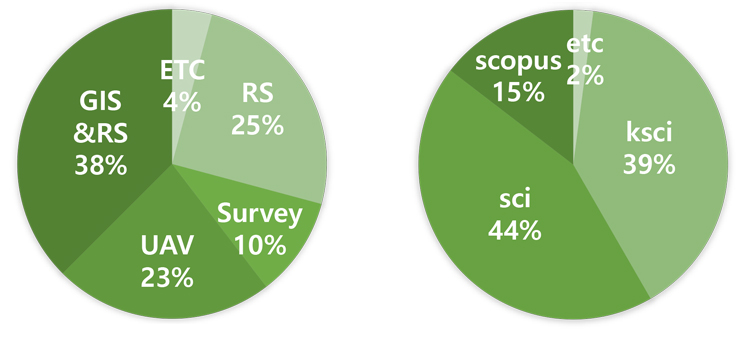
RS : 원격탐사부문
- KARI (항공우주연구원) : KOMPSAT 1,2,3, 3a(대형위성사업) 광학위성 카메라 광학계 품질검사 및 방사학적 정확도 검사
- KARI (항공우주연구원) : CASI-500 1,2호 (중형위성사업) 광학위성 카메라 광학계 품질검사 및 방사학적 정확도 검사
- NAAS (국립농업과학원) : CASI-500 3호 광학계 기술사양 설계 및 검수
- NIFS (국립산업과학원) : CASI-500 3호 광학계 기하학적 정밀도 기술사양 설계 및 알고리즘 제작
- 환경부 : 토지피복지도 품질보장 방안설계 및 품질 검수역
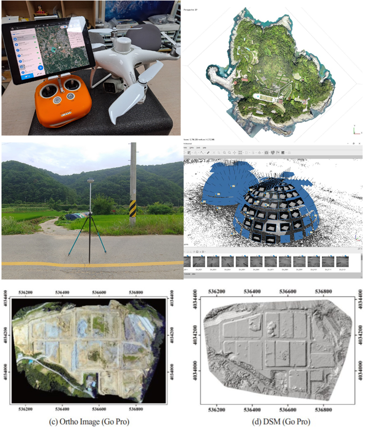
UAV : 무인항공기 부문
- 중기청 : 무인항공기용 고정밀도 카메라 제작사업
- 해양경찰청 및 해군 : 특수목적 무인기 개발사업 및 수심지도 제작기술
- 국립재난연구원 : 단층지도을 위한 고정밀 3차원 라이다 사업
GIS & RS 부문
- 장기 기후변화에 따른 토지피복변화 예측모델 개발
Survey 부문
- 행정안전부 : 지상 2km 고도 10cm 정확도 3차원 지형제작 개발 및 품질검수
- 일반측량 : 항공 lidar정밀도 분석 및 토지피복물 고도 및 성장상태 모델링
- 지질측량 : 자원탐사 및 광물자원량산정
위성 연구
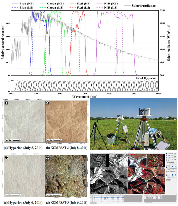
- 고해상도 영상의 정사보정 정확도 검증 및 밴드별 상관성 비교연구
- Absolute radiometric calibration of the KOMPSAT-2 multispectral camera using a reflectance-based metho d and empirical comparison with IKONOS and QuickBird images
- Assessment of smartphone-based technology for remote environmental monitoring and its development
- 다중시기 항공사진과 KOMPSAT-3 영상을 이용한 진하해수욕장 해안선 변화 탐지
- Spatial analysis of Shoreline change in Northwest coast of Taean Peninsula
- Radiometric characterization and validation for the KOMPSAT-3 sensor
- The impact of land use and land cover changes on land surface temperature in the Yangon Urban Area, Myanmar
- Relationship assessment among land use and land cover and land surface temperature over downtown a nd suburban areas in Yangon City, Myanmar
- 다목적실용위성 3호 AEISS 센서의 방사 특성 교차 검증
- Absolute Radiometric Calibration for KOMPSAT-3 AEISS and Cross Calibration Using Landsat-8 OLI
- Updating Absolute Radiometric Characteristics for KOMPSAT-3A and KOMPSAT-3A Multispectral Imaging Sensors Using Well-Characterized Pseudo-Invariant Traps and Microtops Ⅱ
- Radiometric Calibration and Uncertainty Analysis of KOMPSAT-3A Using the Reflectance-Based Method
측량, UAV, 고해상도 위성 및 항공영상 연구
- 스마트폰 카메라의 기하학적 검정과 정확도 평가
- 카메라 기반의 원격 모니터링 시스템을 위한 안드로이드 스마트폰 앱 개발
- Accuracy evaluation of a smartphone-based technology for coastal monitoring
- Feasibility of employing a smartphone as the payload in a photogrammetric UAV system
- 근접수치사진측량을 위한 스마트폰 카메라 검보정
- Assessment of a smartphone-based monitoring systemand its application
- 안드로이드 기반 무인항공 사진측량 시스템 개발
- Feasibility of Using an Automatic Lens Distortion Correction(ALDC) Camera in a Photogrammetric UAV System
- Comparison the Mapping Accuracy of Construction Sites Using UAVs with Low-Cost Cameras
- A Comparative Assessment of the Photogrammertric Accuracy of Mapping Using UAVs with Smart Devices
- A Comparative Study to Evaluate Accuracy on Canopy Height and Density Using UAV, ALS, and Fieldwork
- Evaluating the suitability of the EGM2008 geopotential model for the Korean peninsula using parallel com puting on a diskless cluster
- Development of a Network RTK Positioning and Gravity-Surveying Application with Gravity Correction Usi ng a Smartphone
- 9.12 경주지진의 지진발생기작 예비연구
- 해저지형 표면자료의 GNSS 보정방법에 따른 불확실도 연구
- 경북 청송군 신성리 백악기 사곡층의 공룡발자국화석 퇴적층: 산상 및 고환경
GIS & RS 연구
- 위성영상과 GIS를 이용한 낙동강 하구 지형변화 탐지
- SCS-CN 산정을 위한 수치세부정밀토양도 활용과 괴산군 소수면 소유역의 물유출량 평가
- 낙동강 유역의 토양유실량과 하구지형의 상관성 분석
- Prediction and comparison of urban growth by land suitability index mapping using GIS and RS in South Korea
- Mapping urban growth probability in South Korea: comparison of FR, AHP, and LR models and use of the environ mental conservation value assessment
- 빈도비와 로지스틱 회귀분석 기법을 이용한 도시성장 확률 지도화의 비교
- WebGIS기반의 시뮬레이션 시스템을 위한 지리공간 시뮬레이션 프레임워크 개발
- Soil erosion risk in korean watersheds, assessed using the revised universal soil loss equation
- Landslide susceptibility mapping using frequency ratio, analytic hierarchy process, logistic regression, and artificial n eural network methods at the Inje area, Korea
- Impacts of changes in climate and land use/land cover under IPCC RCP scenarios onstreamflow in the Hoeya River Basin, Korea
- 기후변화 시나리오하의 기후 및 토지피복 변화가 유역 내 유출량에 미치는 영향 분석
- GIS-based landslide susceptibility analyses and cross validation using probabolistic model on two test area in korea
- Impacts of climate change under IPCC RCP scenarios on streamflow and water quality in the younsan basin, south korea
- 대표농도경로 (RCP) 시나리오에 따른 회야강 유역의 미래 유출 및 유사 변화 분석
- Land Use and Land Cover Mapping Based on Band Ratioing with Subpixel Classification by Supoort Vector Machine Tecniques(A Case Study on Ngamoeyeik Dam Area, Yangon Region)
- Forecasting the Potential Effects of Climatic and Land-Use Changes on Shoreline Variation in Relation to Watershed Sediment Supply and Transport
- Simulating land use change in Seoul metropolitan area after greenbelt elimination using the SLEUTH model
-

진청길
- 직급
- 박사과정
- cgjin@pukyong.ac.kr
- 학위
- 부경대학교 지구환경시스템과학부 공간정보시스템공학전공(공학석사)
- 주요 연구내용
- 광학영상의 검보정기법 개발 및 검증
-

김민지
- 직급
- 석사과정
- jiya2123@pukyong.ac.kr
- 학위
- 부경대학교 공간정보시스템공학과(공학사)
- 주요 연구내용
- -
-

이세진
- 직급
- 학부과정
- leesejin1045@naver.com
- 학위
- -
- 주요 연구내용
- -
-

TESHOME EYOAL GETACHEW
- 직급
- 석사과정
- eyoal1getachew@gmail.com
- 학위
- -
- 주요 연구내용
- -
-
김연수
- 학위 : 부경대학교 대학원 지구환경공학연협동(공학박사)
- 주요 연구내용 : S & MBES를 이용한 연안측량 정확도 개선 방안 연구
- 현재 : 한국해양조사협회 본부장
-
이창헌
- 학위 : 부경대학교 지구환경시스템과학부 공간정보시스템공학전공(공학박사)
- 주요 연구내용 : 고해상도 위성영상과 라이다 데이터를 이용한 비오톱지도 제작 및 정확도 검증에 관한 연구
- 현재 : 부산발전연구원 부연구위원
-
황창수
- 학위 : 부경대학교 지구환경시스템과학부 공간정보시스템공학전공(공학박사)
- 주요 연구내용 : 유류오염 포텐셜 해석을 통한 방제대책 수립 방법에 관한 연구
- 현재 : 국립해양조사원 수로측량과 사무관
-
조성환
- 학위 : 부경대학교 대학원 지구환경공학연협동(공학석사)
- 주요 연구내용 : 정사항공사진을 이용한 장기간 지형 변화에 관한 연구
- 현재 : 지오션 부사장
-
김호용
- 학위 : 부경대학교 대학원 위성정보과학과(공학석사)
- 주요 연구내용 : 장기해안지형변화분석을 위한 2D.3D 모니터링 기법 비교 연구
- 현재 : 해양정보기술 상무
-
이은경
- 학위 : 부경대학교 대학원 위성정보과학과(공학석사)
- 주요 연구내용 : 소형 다중분광 항공촬영시스템(PKNU3호) 개발 및 환경원격탐사 가능성 평가에 관한 연구
- 현재 : 한의사
-
조남춘
- 학위 : 부경대학교 대학원 위성정보과학과(공학석사)
- 주요 연구내용 : RS와 GIS 기법을 활용한 산사태 특성분석 및 위험지도 검증
- 현재 : 대한민국 공군 군무원
-
최연주
- 학위 : 부경대학교 산업대학원 공간정보공학과(공학석사)
- 주요 연구내용 : 고해상도 인공위성을 이용한 TOF의 자원량 평가 -제주도 서귀포시 방품림을 대상으로-
- 현재 : 한국해양기술 차장
-
윤동건
- 학위 : 부경대학교 대학원 위성정보과학과(공학석사)
- 주요 연구내용 : 선박동적 거동특성을 고려한 조위보정 신기술에 관한 연구
- 현재 : 국방부 사무관
-
양지연
- 학위 : 부경대학교 대학원 위성정보과학과(공학석사)
- 주요 연구내용 : GIS/RS를 이용한 해운대 해수욕장의 해안지형 및 토지피복 변화 분석
- 현재 : 캐나다 유학
-
홍현정
- 학위 : 부경대학교 대학원 위성정보과학과(공학석사)
- 주요 연구내용 : GIS 기법을 활용한 해운대 해저, 해빈지형의 3차원 변화 탐지 및 분석
- 현재 : 환경정책평가연구원 선임연구원
-
박용범
- 학위 : 부경대학교 대학원 위성정보과학과(공학석사)
- 주요 연구내용 : 소형 무인 항공촬영시스템 개발 및 활용에 관한 연구
- 현재 : 산림조합원 위성사진 판독사
-
김지용
- 학위 : 부경대학교 대학원 위성정보과학과(공학석사)
- 주요 연구내용 : 3차원 공간정보를 이용한 해운대 해수욕장의 해안지형 변화 분석
- 현재 : 중앙항업 선임연구원
-
마정림
- 학위 : 부경대학교 위성정보과학과(공학사)
- 주요 연구내용 :
- 현재 : 산림조합원 과장
-
신병근
- 학위 : 부경대학교 위성정보과학과(공학사)
- 주요 연구내용 :
- 현재 :
-
김은선
- 학위 : 부경대학교 환경대기 및 위성정보과학과군 위성정보과학과(공학사)
- 주요 연구내용 :
- 현재 : 항공우주연구원 전임 연구원
-
오치영
- 학위 : 부경대학교 지구환경시스템과학부 위성정보과학과(공학석사)
- 주요 연구내용 : 공간정보를 이용한 장기간의 낙동강 하구 지형변화 분석
- 현재 : 한국해양조사협회 성과심사팀 계장
-
손정우
- 학위 : 부경대학교 지구환경시스템과학부 위성정보과학과(공학석사)
- 주요 연구내용 : Landsat ETM+ 영상의 지표면온도변화를 이용한 환경변화 탐지 및 분석
- 현재 : 부산발전연구원
-
진청길
- 학위 : 부경대학교 지구환경시스템과학부 공간정보시스템공학전공(공학석사)
- 주요 연구내용 : KOMPSAT-2 고해상도 위성영상의 상대복사보정 및 검증
- 현재 : 항공우주연구원 자료검보정처리팀
-
박중수
- 학위 : 부경대학교 지구환경시스템과학부 공간정보시스템공학전공(공학석사)
- 주요 연구내용 : eGIS를 이용한 다문화학생의 교육수요 분석 및 미래예측
- 현재 : 동의공업고등학교 측량과 교사
-
박소영
- 학위 : 부경대학교 지구환경시스템과학부 공간정보시스템공학전공(공학박사)
- 주요 연구내용 : 도시성장모델링
- 현재 : LX 한국국토정보공사 국토정보교육원 교수
-
이성규
- 학위 : 부경대학교 지구환경시스템과학부 공간정보시스템공학전공(공학박사)
- 주요 연구내용 : 병렬 컴퓨팅을 이용한 지오이드 모델 개선과 GNSS/중력 통합 측량시스템 개발
- 현재 : 기상청-APEC 기후센터
-
윤명현
- 학위 : 부경대학교 지구환경시스템과학부 공간정보시스템공학전공(공학석사)
- 주요 연구내용 : 태안 지역의 과거부터 현재까지 기 촬영된 위성영상 및 항공 LiDAR 자료를 수집ㆍ분석하여 해안선 변화를 탐지함으로써 해안 환경의 침식 및 퇴적 변화를 정량적으로 분석하고 예측연구.
- 현재 : 한국해양조사협회 대리
-
이주호
- 학위 : 부경대학교 공간정보시스템공학과(공학사)
- 주요 연구내용 :
- 현재 : 마린리서치 대리
-
박진우
- 학위 : 부경대학교 지구환경시스템과학부 공간정보시스템공학전공(공학박사수료)
- 주요 연구내용 : 오픈소스 GIS 및 개발
- 현재 :
-
안호용
- 학위 : 부경대학교 지구환경시스템과학부 공간정보시스템공학전공(공학박사)
- 주요 연구내용 : 고해상도 위성/초분광 영상 방사검보정 연구
- 현재 : 국립농업과학원 연구사
-
신동윤
- 학위 : 부경대학교 지구환경시스템과학부 공간정보시스템공학전공(공학석사)
- 주요 연구내용 : 다목적실요우이성 3호의 절대복사보정과 교차검보정
- 현재 : 국립재난안전연구원 재난원인조사실 연구원
-
KHIN MAR YEE
- 학위 : 부경대학교 지구환경시스템과학부 공간정보시스템공학전공(공학박사)
- 주요 연구내용 : The Impact of Land Use and Land Cover Changes on Land Surface Temperature in Yangon City Area, Myanmar
- 현재 : DAGON University Associate Professor
-
정호현
- 학위: 부경대학교 지구환경시스템과학부 공간정보시스템공학전공(공학박사)
- 주요 연구내용: UAV 시스템을 활용한 연구(제작, 개발, 운용, 활용)
- 현재: LX 한국국토정보공사 공간정보연구원 융복합연구실 선임연구원
-
신상현
- 학위: 부경대학교 지구환경시스템과학부 공간정보시스템공학전공(공학석사)
- 주요 연구내용: UAV 항공사진과 항공 Lidar를 이용한 수고측량에 대한 비교연구
- 현재:
-
이다은
- 학위: 부경대학교 공간정보시스템공학전공(공학사)
- 주요 연구내용: 항공사진을 이용한 3D 모델링
- 현재: SK임업
-
추성원
- 학위: 부경대학교 공간정보시스템공학전공(공학사)
- 주요 연구내용: 3D 모델링 및 측량정보공학
- 현재: ㈜올포랜드
국외논문 (최근 10개년)
- Kim, Minji, Jin, Cheonggil, Lee, Sejin, Kim, Kyoung-Min, Lim, Joongbin, Choi, Chuluong, 2022, Calibration of BRDF Based on the Field Goniometer System Using a UAV Multispectral Camera, Sensors, 22(19).
- Jin, Cheonggil, Ahn, Hoyong, Seo, Doochun, Choi, Chuluong, 2020, Radiometric Calibration and Uncertainty Analysis of KOMPSAT-3A Using the Reflectance-Based Method, Sensors, 20(9).
- Jin, Cheonggil, Oh, Che-young, Shin, Sanghyun, Wilfred Njungwi, Nkwain, Choi, Chuluong, 2020, A Comparative Study to Evaluate Accuracy on Canopy Height and Density Using UAV, ALS, and Fieldwork, Forests, 11(2).
- Yeom, Jong-Min, Ko, Jonghan, Hwang, Jisoo, Lee, Chang-Suk, Choi, Chul-Uong, Jeong, Seungtaek, 2018, Updating Absolute Radiometric Characteristics for KOMPSAT-3 and KOMPSAT-3A Multispectral Imaging Sensors Using Well-Characterized Pseudo-Invariant Tarps and Microtops II, Remote Sensing, 10(5).
- Jeong, Hohyun; Ahn, Hoyong; Shin, Dongyoon; Ahn, Yushin; Choi, Chuluong, 2019, A Comparative Assessment of the Photogrammertric Accuracy of Mapping Using UAVs with Smart Devices, Photogrammetric Engineering & Remote Sensing, 85(12), 889-897.
- Soyoung Park, Keith C. Clarke, Chuluong Choi, Jinsoo Kim., 2017, "Simulating Land Use Change in the Seoul Metropolitan Area after Greenbelt Elimination Using the SLEUTH Model", Journal of Sensors, vol. 2017, Article ID 4012929, 18 pages,
- Kim. Jinsoo, Choi. Jisun, Choi. Chuluong, Hwang. Changsu, 2017, Forecasting the Potential Effects of Climatic and Land-Use Changes on Shoreline Variation in Relation to Watershed Sediment Supply and Transport, Journal of Coastal Research, 33(4), 874-888
- Relationship assessment among land use and land cover and land surface temperature over downtown and suburban areas in Yangon City, Myanmar
- Khin Mar Yee, Khine Phoo Wai, Bak Jinhyung and Choi Chul Uong, Land Use and Land Cover Mapping Based on Band Ratioing with Subpixel Classification by Support Vector Machine Techniques (A Case Study on Ngamoeyeik Dam Area, Yangon Region), 2015, 3(3), 127-133
- Jinsoo Kim,Cheonggil Jin,Chuluong Choi &Hoyong Ahn, 2015, Radiometric characterization and validation for the KOMPSAT-3 sensor, Remote Sensing Letters, 6(7), 529-538.
- B.Y. Ryu, H.J. Jung, S.H. Bae, C.U. Choi, 2013, Estimation of carbon dioxide emissions per urban center link unit using data collected by the Advanced Traffic Information System in Daejeon, Korea, Atmospheric Environment, 81, 433-442
- Choi Jisun, Park Soyoung, Yeu Yeon, Yoon Hong-Joo, Choi Chuluong, Kim Jinsoo, 2013, Impacts of climate change under IPCC RCP scenarios on streamflow and water quality in the younsan basin, south korea, Disaster Advanced, 6(12), 134-141
- Kim Jinsoo, Choi Culuong, Park Soyoung, 2013, GIS-based landslide susceptibility analyses and cross validation using probabolistic model on two test area in korea, Disaster Advanced, 6(10), 45-54
- Kim Jinsoo, Lee Youngcheol, Cha Sungyeoul, Choi Chuluong, Lee Seongkyu, 2013, Development of a Network RTK Positioning and Gravity-Surveying Application with Gravity Correction Using a Smartphone, Sensors, 13(7), 8879-8894
- Jinsoo Kim, Jisun Choi, Chuluong Choi, Soyoung Park, 2013, Impacts of changes in climate and land use/land cover under IPCC RCP scenarios on streamflow in the Hoeya River Basin, Korea, Science of The Total Environment, 452–453, 181-195
- Jinsoo Kim, Seongkyu Lee, Hoyong Ahn, Dongju Seo, Soyoung Park, Chuluong Choi, 2013, Feasibility of employing a smartphone as the payload in a photogrammetric UAV system, ISPRS Journal of Photogrammetry and Remote Sensing, 79, 1-18
- Jin Cheonggil, Ahn Hoyong, Seo Doochun, Choi Chuluong, 2012, Absolute radiometric calibration of the KOMPSAT-2 multispectral camera using a reflectance-based method and empirical comparison with IKONOS and QuickBird images, Journal of Applied Remote Sensing, 6(1), 1-26
- Seongkyu Lee, Chuluong Choi, Jinsoo Kim, 2013, Evaluating the suitability of the EGM2008 geopotential model for the Korean peninsula using parallel computing on a diskless cluster, Computers & Geosciences, 52, 132-145,
- Park, Soyoung, Choi, Chuluong., Kim, Byungwoo. Kim, Jinsoo, 2013, Landslide susceptibility mapping using frequency ratio, analytic hierarchy process, logistic regression, and artificial neural network methods at the Inje area, Korea. Environmental Earth Sciences, 68(5), 1443–1464
- Seongkyu Lee , Jinsoo Kim , Cheonggil Jin , Sanghoon Bae, Chuluong Choi, 2012, ASSESSMENT OF SMARTPHONE-BASED TECHNOLOGY FOR REMOTE ENVIRONMENTAL MONITORING AND ITS DEVELOPMENT, Instrumentation Science & Technology, 40:6, 504-529
- Jinsoo Kim, Seongkyu Lee, Hoyong Ahn, Dongju Seo, Doochun Seo, Jongchool Lee, 2013 Chuluong Choi, Accuracy evaluation of a smartphone-based technology for coastal monitoring, Measurement, 46(1), 233-248
- Park S Y, Jin C G, Jeon S W, Jung H C, Choi C U, 2010, Soil Erosion Risk in Korean Watersheds, Assessed Using the Revised Universal Soil Loss Equation, Journal of hydrology, (ACCEPT), 399(3_4), 263-273 (Impact factor : 2.843)
- Park S Y, Jeon S Y, Choi C U, 2010, Mapping urban growth probability in South Korea: comparison of FR, AHP, and LR models and use of the environmental conservation value assessment, Landscape and Ecological Engineering, 8(1), 17-31 (Impact factor : 3.554)
- Park S Y, Jeon S Y, Kim S Y, Choi C U, 2010, Prediction and comparison of urban growth by land suitability index mapping using GIS and RS in South Korea, Landscape and Urban Planning, 99(2), 104-114 (Impact factor : 3.171)
- Yang J Y, Seo D C, Lim H S, Choi C U, 2010, An analysis of coastal topography and landcover changes at Haeundae Beach, South Korea, Acta Astronautica, 66(9-10), 1280-1288 (Impact factor : 0.508)
- Park S Y, Jin C G, Kim S Y, Jo K C, Choi C U, 2010, A Comparison of Urban Growth Probability Maps Created Using Frequency Ratio and Logistic Regression Methods, Journal of Korean institute of landscape architecture, 38(5_2),.194-205
국내 논문
- Njungwi, N. W., Lee, D., Kim, M., Jin, C., & Choi, C. (2021). Analyzing the Evolution of Summer Thermal Anomalies in Busan Using Remote Sensing and Spatial Statistical Tool. Korean Journal of Remote Sensing, 37(4), 665–685.
- Jin, C., & Choi, C. (2021). The Assessment of Cross Calibration/Validation Accuracy for KOMPSAT-3 Using Landsat 8 and 6S. Korean Journal of Remote Sensing, 37(1), 123–137.
- Choi, W., Lee, H., Choi, C., Lee, Y., & Noh, Y. (2020). UV-VIS 초분광 위성센서 모의복사휘도를 활용한 다양한 관측환경에서의 에어로솔 유효고도에 대한 O4 대기질량인자 민감도 조사. 대한원격탐사학회지, 36(2_1), 155–165.
- 김현주, 황구근, 정호현, 안호용, 최철웅, 임현수, 최태진, 채용운, 백인성 (2019). 경북 청송군 신성리 백 악기 사곡층의 공룡발자국화석 퇴적층: 산상 및 고환경. 지질학회지, 55(5), 495-511.
- OH, C.-Y., KIM, H.-Y., LEE, Y.-S., & CHOI, C.-U. (2019). 해저지형 표면자료의 GNSS 보정방법에 따른 불확실도 연구. 한국지리정보학회지, 22(3), 1–9.
- Jeong, H., Ahn, H., Shin, D., & Choi, C. (2019). Comparison the Mapping Accuracy of Construction Sites Using UAVs with Low-Cost Cameras. 대한원격탐사학회지, 35(1), 1–13.
- Ahn, Hoyong, Shin, Dongyoon, Lee, Sungu, Choi, Chuluong (2017). Absolute Radiometric Calibration for KOMPSAT-3 AEISS and Cross Calibration Using Landsat-8 OLI. 한국측량학회지, 35(4), 291-302
- Kim, Y.-S., Kim, T., Kyung, J. B., Cho, C. S., Choi, J.-H., & Choi, C. U. (2017). Preliminary study on rupture mechanism of the 9.12 Gyeongju Earthquake. Journal of the Geological Society of Korea, 53(3), 407–422.
- Yee, K. M., Ahn, H., Shin, D., & Choi, C. (2016). The impact of land use and land cover changes on land surface temperature in the Yangon Urban Area, Myanmar. 대한원격탐사학회지, 32(1), 39–48.
- Shin, Dongyoon, Choi, Chul-uong, Lee, Sun-gu, & Ahn, Ho-yong. (2016). 다목적실용위성 3호 AEISS센서의 방사 특성 교차 검증. 대한원격탐사학회지, 32(5), 529–538.
- Yee, K. M., Ahn, H., Shin, D., & Choi, C. (2016). Relationship assessment among land use and land cover and land surface temperature over downtown and suburban areas in Yangon City, Myanmar. 대한원격탐사학회지, 32(4), 353–364.
- Jeong, Hohyun, Ahn, Hoyong, Park, Jinwoo, Kim, Hyungwoo, Kim, Sangseok, Lee, Yangwon, Choi, Chuluong, (2015), Feasibility of Using an Automatic Lens Distortion Correction (ALDC) Camera in a Photogrammetric UAV System. 한국측량학회지, 33(6), 475-483.
- 박진우(Jinwoo Park), 신동윤(Dongyoon Shin), 최철웅(Chuluong Choi),and 정호현(Hohyun Jeong), 2015, "연구논문 : 안드로이드 기반 무인항공 사진측량 시스템 개발." 大韓遠隔探査學會誌 31(3) , 215-226.
- Yun, M., & Choi, C, 2015, Spatial analysis of Shoreline change in Northwest coast of Taean Peninsula. 대한원격탐사학회지, 31(1), 29–38.
- 황창수(Hwang Chang Su),최철웅(Choi Chul Uong),and 최지선(Choi Ji Sun), 2014, "대표농도경로 (RCP) 시나리오에 따른 회야강 유역의 미래 유출 및 유사 변화 분석." 대한공간정보학회지 22(3), 11-19.
- 황창수 ( Chang Su Hwang ),최철웅 ( Chul Uong Choi ),and 최지선 ( Ji Sun Choi ), 2014, 다중시기 항공사진과 KOMPSAT-3 영상을 이용한 진하해수욕장 해안선 변화 탐지, 大韓遠隔探査學會誌 30(5), 607-616.
- Ahn Ho-yong, Choi Chul-uong, Yeu Yeon. 2014, Assessment of a smartphone-based monitoring system and its application. 대한원격탐사학회지 30(3), 383–397.
- 윤명현, 유연, 최철웅, 박진우, 2014, 근접수치사진측량을 위한 스마트폰 카메라 검보정, 대한원격탐사학회, 30(1), 149-160.
- 김진수, 최철웅, 2013, 기후변화 시나리오하의 기후 및 토지피복 변화가 유역 내 유출량에 미치는 영향 분석, 대한공간정보학회지 21(3), 107-116.
- 이성규, 김진수, 김영섭, 최철웅, 2011, 카메라 기반의 원격 모니터링 시스템을 위한 안드로이드 스마트폰 앱 개발, 대한공간정보학회 19(5), 87-96.
- 김진수, 진청길, 이성규, 이선구, 최철웅, 2011, 스마트폰 카메라의 기하학적 검정과 정확도 평가, 대한공간정보학회 19(3), 115-125.
- 이성규, 김영섭, 최철웅, 서용철, 2010, WebGIS기반의 시뮬레이션 시스템을 위한 지리공간 시뮬레이션 프레임워크 개발, 한국공간정보학회 18(5), 119-131.
- 황창수, 김경탁, 오치영, 진청길, 최철웅, 2010, 낙동강 유역의 토양유실량과 하구지형의 상관성 분석, 한국지형공간정보학회지 18(3), 3-10.
- 홍석영, 정강호, 최철웅, 장민원, 김이현, 손연규, 하상건, 2010, SCS-CN 산정을 위한 수치세부정밀토양도 활용과 괴산군 소수면 소유역의 물 유출량 평가, 한국토양비료학회지 43(3), 363-373.
- 진청길, 박소영, 김형석, 천용식, 최철웅 2010, 고해상도 영상의 정사보정 정확도 검증 및 밴드별 상관성 비교 연구, 한국지형공간정보학회지 18(2), 35-45.
- 오치영, 박소영, 최철웅, 전성우, 2010, 위성영상과 GIS를 이용한 낙동강하구 지형변화탐지, 한국지형공간정보학회지 18(1), 21-29.
- 오치영, 박소영, 김형석, 이양원, 최철웅, 2010, 고해상도 위성영상의 토지피복분류와 정확도 비교 연구, 한국지리정보학회지 13(1), 89-100.
- 박소영, 전성우, 최철웅, 2009, 행정구역 위계별 도시성장 패턴 및 특성 분석 : 1985~2005를 중심으로, 한국지리정보학회지 12(4), 34-47.
- 손정우, 전성우, 최철웅, 2009, GIS와 통계기법을 이용한 대한민국 도시확장 패턴분석, 한국지형공간정보학회지 17(4), 13-22.
- 오치영, 김경탁, 최철웅, 2009, SPOT5 영상과 GIS분석을 이용한 인제 지역의 산사태 특성 분석, 대한원격탐사학회지 25(5), 445-454.
- 최철웅, 이창헌, 오치영, 손정우, 2009, 수치항공사진을 이용한 해안선 침퇴적변화에 관한 연구, 한국지형공간정보학회지 17(3), 23-31.
- 최철웅, 이창헌, 서용철, 김지용, 2009, Landsat 영상을 이용한 변화탐지 분석 기법 연구, 한국지리정보학회지 12(3), 13-20.
- 손정우, 김경탁, 이창헌, 최철웅, 2009, 항공사진과 GIS를 이용한 인제지역 산사태 분석, 한국지형공간정보학회지 17(2), 61-69.
- 최철웅, 오치영, 이창헌, 2009, 공간정보를 이용한 광안리 해안선 변화에 관한 연구, 한국지형공간정보학회지, 17(1), 13-19.
- 최철웅, 손정우, 이창헌, 2009, GIS를 이용한 해운대구 토지가치 분석, 한국지형곤강정보학회지 17(2), 3-9
- 홍현정. 최철웅, 한경수, 전성우 2006, RS, GIS 기법을 활용한 해운대 해저, 해빈지형의 3차원 입체변화 탐지 및 분석, 대한원격탐사학회지 22(4), 243-253
- 조남춘, 최철웅, 전성우, 한경수, 2006, RS와 GIS 기법을 활용한 산사태 위험성의 검증, 한국지리정보학회지 9(2), 54-66
- 양지연, 최철웅, 2006, 해운대 해수욕장의 해안지형 및 토지피복 변화 분석, 한국지리정보학회지 9(1), 101-115
- 최철웅, 김연수, 서용철, 2005, 정사항공사진과 해양조사측량을 이용한 해안선변화 탐지에 관한 연구 : 포락지 중심으로, 한국해안해양공학회지 17(2), 61-69
- 최철웅, 김연수, 서용철, 2005, 다중심 음향측심기 수심 정확도 개선, 한국측량학회지 23(1), 1-8
- Lee E K, Choi C U, Suh Y C, 2005, Development of PKNU3 : A small-format, multi-spectral, aerial photographic system, Korean Journal of Remote Sensing 20(5), 337-351
- 김호용, 최철웅, 2005, 광안리 지역의 장기 지형변화에 관한 연구, 대한토목학회지 25(1), 203-211
- 이창헌, 최철웅, 2004, PKNU2호 영상을 이용한 정사영상 지도 제작 및 3차원 입체 분석, 한국지리정보학회지 7(4), 77-87
- 이은경, 최철웅, 2004, 다중분광 항공촬영 시스템(PKNU 3) 검정 및 보정에 관한 연구, 한국지리정보학회지 7(4), 143-154
- 최철웅, 김연수, 2004, DGPS와 Motion Sensor를 이용한 선박 동적 거동특성, 한국지형공간정보학회지 12(4), 35-43
- 최철웅, 김호용, 전성우, 2003, 다중영상촬영을 위한 PKNU2호 개발에 관한 연구, 대한원격탐사학회지 19(4), 291-305
- 이은경, 이창헌, 최철웅, 김영섭 2003, 다중분광 항공촬영시스템(PKNU2호)를 이용한 정사영상지도 제작 가능성에 관한 연구 대한토목학회논문집 23(6D), 883-890
- 서영상, 최철웅, 이나경, 김복기, 장이현, 2002, Panchromatic 위성 자료를 이용한 선박 확인의 접근 기법, 한국지리정보학회지 5(4), 82~92
- 최철웅, 김영섭, 남광우, 2002, A Comparative Study of Urban Coastline Change Involving Natural and Artificial Shores, 대한국토·도시계획학회 37(6), 173-185
- 최철웅, 김형석, 2001, 수치항공사진 기법을 이용한 광안리 해수욕장 해안선 변화에 관한 연구, 한국수산자원학회지 4(1), 73~85
- 남광우, 이성호, 최철웅, 2001, 부산시 인구성장의 조정과정에 관한 연구, 대한국토·도시계획학회지 36(7), 257-270
- 최철웅, 김영섭, 2001, 수치항공사진을 이용한 해운대해수욕장 해안선변화에 관한 연구, 한국지리정보학회지 4(4), 39-50
- 최철웅, 강인준, 2001, 지형공가정보의 민감도에 따른 수문학적 영향분석에 관한 연구, 대한토목학회지논문집 21(1D), 87-95
국외 학술발표
| 발표연도 | 제목 | 회의명 | 주관기관 |
|---|---|---|---|
| 2018.02.07 | Radiometric Cross Calibration of Kompsat-3 | ASPRS Annual Conference and International Lidar Mapping Forum | ASPRS |
| 2018.02.06. | Accuracy Evaluation for the UAV Photogrammetric Image of 3D Modeling | ASPRS Annual Conference and International Lidar Mapping Forum | ASPRS |
| 2017.08.28 | UAV Photogrammetric Accuracy Assessent for High-Resolution Reconstruction of Mapping and 3D Modelling | Asia-Pacific Conference on Engineering and Applied Sciences | Higher Education Forum(HEF) |
| 2016.07.19 | Development of Open sourcebasedAutomatic shooting and processingUAS imagery for Orthoimage Using SmartCamera UAV | XXIII ISPRS CONGRESS | ISPRS |
| 2016.07.18 | Absolute Radiometric Calibration ofKOMPSAT-3A | XXIII ISPRS CONGRESS | ISPRS |
| 2016.07.18 | Radiometric Cross-calibration ofKOMPSAT-3A with Landsat-8 | XXIII ISPRS CONGRESS | ISPRS |
| 2016.07.17 | Accuracy Assessment for OrthoimageUsing Smart Camera UAV | XXIII ISPRS CONGRESS | ISPRS |
| 2016.06.02 | Feasibility of Using the Smart Camera in a Photogrammetric UAV | International Conference on Agriculture & Forestry | TIIKM |
| 2016.04.20 | Absolute Radiometric Calibration KOMPSAT-3A Using Reflectance-Based Method | International Symposium on Remote Sensing 2016 | KSRS, RSSJ, CSPRS, EMSEA |
| 2015.10.20 | Radiometric Calibration of the KOMPSAT-3 | The 36th Asian Conference on Remote Sensing | ACRS 2015 |
| 2015.10.20 | An Observatory of Land Surface Temperature Changes by Land Use and Land Cover Changes of Yangon Mea City, Myanmar | The 36th Asian Conference on Remote Sensing | ACRS 2015 |
| 2015.09.23 | Vicarious calibration of KOMPSAT-3 AEISS | SPIE REMOTE SENSING (2015) | SPIE |
| 2015.09.22 | Applicability research of ALDC camera for the application of unmanned aerial vehicle | SPIE REMOTE SENSING (2015) | SPIE |
| 2015.09.22 | Radiometric cross-calibration of KOMPSAT-3 with Landsat-8 | SPIE REMOTE SENSING (2015) | SPIE |
| 2015.09.16 | Development of Opensource-based Photogrammetric UAV System Using Smart Camera | Free and Open Source Software For Geospatial Conference | OSGeo |
| 2015.05.07 | LAND SURFACE TEMPERATURE CHANGES BY LAND COVERCHANGES OF INLAY LAKE AREA, MYANAMAR | Imaging and Geospatial Technology Forum (IGTF) | American Society of Photogrammetry and Remote Sensing |
| 2015.05.06 | LAND SURFACE TEMPERATURE CHANGES BY LAND COVERCHANGES OF INLAY LAKE AREA, MYANAMAR | Imaging and Geospatial Technology Forum (IGTF) | American Society of Photogrammetry and Remote Sensing |
| 2015.05.06 | Development of Automatic shooting and telemetry system for UAV photogrammetry | Imaging and Geospatial Technology Forum (IGTF) | American Society of Photogrammetry and Remote Sensing |
| 2014.10.30 | Smart Camera calibration for Photogrammetry application | The 35th Asian Conference on Remote Sensing 2014 | ACRS 2014 |
| 2014.10.30 | SPATIAL ANALYSIS OF THE TAEAN SHORELINE CHANGEUSING SATELLITE IMAGE AND GIS | The 35th Asian Conference on Remote Sensing 2014 | ACRS 2014 |
| 2014.10.30 | Study of Surface Temperature with Land cover Change using Landsat | The 35th Asian Conference on Remote Sensing 2014 | ACRS 2014 |
| 2014.10.30 | LAND USE AND LAND COVER CLASSIFICATION MAPPING BASED ON BAND RATIOING WITH SUBPIXEL OF SUPPORT VECTOR MACHINE TECHNIQUES (A CASE STUDY ON NGAMOEYEIK DAM AREA, YANGON REGION) | The 35th Asian Conference on Remote Sensing 2014 | ACRS 2014 |
| 2014.10.29. | DEVELOPMENT OF A SMART DEVICE-BASED TELEMETRY AND PHOTOGRAPING SYSTEM FOR PHOTOGRAMMETRIC UAV SYSTEM ON NON-VISIBLE AREA | The 35th Asian Conference on Remote Sensing 2014 | ACRS 2014 |
| 2013.10.22. | Assessment of Climate Change Impact on Streamflow and Water Quality of Kumho River Basin, South Korea | The 34th Asian Conference on Remote Sensing | Indonesian Remote Sensing Society and Asian Association on Remote Sensing |
| 2013.10.21. | Assessment of Smartphone Camera in Closed-range Digital Photogrammetry | The 34th Asian Conference on Remote Sensing | The 34th Asian Conference on Remote Sensing |
| 2013.10.21. | Development of a Gravity Correction Service Using OGC Web Processing Service | The 34th Asian Conference on Remote Sensing | Indonesian Remote Sensing Society and Asian Association on Remote Sensing |
| 2013.10.21. | Development of Android Smartphone App for GCP Serveying Using Total Station | The 34th Asian Conference on Remote Sensing | Indonesian Remote Sensing Society and Asian Association on Remote Sensing |
| 2013.03.26. | Implementation of a Stereo Camera App Based on Smartphone with Bluetooth | ASPRS 2013 Annual Conference | The American Society for Photogrammetry and Remote Sensing |
| 2012.10.10 | Development of a low-cost UAV using smartphone | ISRS 2012 ICSANE | Korean Society of Remote Sensing |
| 2012.08.31. | Application possibility of smartphone as payload for photogrammetric UAV system | The XXII Congress of the International Society for Photogrammetry and Remote Sensing | International Society for Photogrammetry and Remote Sensing |
| 2012.08.25. | Implementation of the Distributed Parallel Program for Geoid Heights Computation Using MPI and Open MP | The XXII Congress of the International Society for Photogrammetry and Remote Sensing | International Society for Photogrammetry and Remote Sensing |
| 2012.03.21. | The Accuracy Evaluation of Smartphone-Based Technique for Coastal Monitering | ASPRS 2012 Annual Conference | The American Society for Photogrammetry and Remote Sensing |
| 2011.09.21. | A Comparative Study of Relationship to Solar Radiation and Extraction of Vegetation : Using Kompsat-2 and IKONOS Image | SPIE Remote Sensing | Spie-Int Society Optical Engineering |
| 2011.09.21. | A Study of Calibration KOMPSAT-2 Image by Relative Radiometric Calibration. | SPIE Remote Sensing | Spie-Int Society Optical Engineering |
| 2011.09.21. | An Ecosystem Service Value Assessment of Land-use Change in South Korea Using Remote Sensing Data and Geographic Information System | SPIE Remote Sensing | Spie-Int Society Optical Engineering |
| 2011.09.19. | Predicting Soil Erosion under Land-cover area and Climate Changes Using the Revised Universal Soil Loss Equation | SPIE Remote Sensing | Spie-Int Society Optical Engineering |
| 2010.11.04. | Predicting Soil Erosion By Change of Land-cover and Rainfall Using the Revised Universal Soil Loss Equation | The 31st Asian Conference on Remote Sensing | Asian Association on Remote Sensing |
| 2010.11.02. | Ecosystem Service Value Assessment by Change of Landcover Area in South Korea | The 31st Asian Conference on Remote Sensing | Asian Association on Remote Sensing |
| 2010.11.02. | Mapping Urban Growth Probabilty in South Korea : Comparision of Environmental Damage by Use of Environmental Conservation Value Assessment Map | The 31st Asian Conference on Remote Sensing | Asian Association on Remote Sensing |
| 2010.10.28. | A Study on the Estimation of Building Area Using LIDAR Data and Aerial Images | ISRS 2010 ICSANE | Korean Society of Remote Sensing |
| 2010.10.28. | Analysis and Forecasting of Land-cover Area Changes by Environmental Conservation Value Assessment Map | ISRS 2010 ICSANE | Korean Society of Remote Sensing |
| 2010.10.28. | Geospatial Research Framework Utilizing Various Datasets and Statistical Models : a Case Study of Future Urban Growth | ISRS 2010 ICSANE | Korean Society of Remote Sensing |
| 2010.10.20. | Fishery damage investigation caused by construction of Gwangyang LNG Combined Cycle Thermal Power Plant and thermal discharge | PORSEC 2010 Connecting Regional Impacts to Global Environmental Change | PORSEC |
| 2010.07.11. | The Comparative Research of Landslide Susceptibility Mapping Using FR, AHP, LR, ANN | ESRI User Conference 2010 | ESRI User Conference |
| 2009.10.29 | Analysis of Landslide in Inje Area Using GIS Analysis | International Symposium on Remote Sensing 2009 | Korean Society of Remote Sensing |
| 2009.10.29 | GIS And Statistical Techniques Used in Korea Urban Environment Change Trend Analysis | International Symposium on Remote Sensing 2009 | Korean Society of Remote Sensing |
| 2009.10.29 | The Pattern and Structural Analysis of Urban and Build Up Growth Each Patch Size During 20 years (1985~2005) | International Symposium on Remote Sensing 2009 | Korean Society of Remote Sensing |
| 2009.10.28 | Analysis On Coastal Topography Change In Haeundae Beach Using LIDAR Data | International Symposium on Remote Sensing 2009 | Korean Society of Remote Sensing |
| 2009.10.28 | Change Detection at the Nakdong Estuary Delta using Satellite Image | International Symposium on Remote Sensing 2009 | International Symposium on Remote Sensing 2009 |
| 2008.11.12. | An analysis of Haeundae Beach Coastal Topography change by Sea Level Rise | The 29th Asian Conference on Remote Sensing | Asian Conference on Remote Sensing |
| 2008.11.12. | Busan of separately declared land value fluctuation analysis using GIS & RS | The 29th Asian Conference on Remote Sensing | Asian Conference on Remote Sensing |
| 2008.11.11. | Detection on seasonal changes in the Haeundae | The 29th Asian Conference on Remote Sensing | Asian Conference on Remote Sensing |
| 2008.11.11. | Research for a Long-term Topographic Changes of the Kwoangan-bridge Construction Kwoangan-bridge Construction Research for a Long-term Topographic Changes of the Kwoangan-bridge Construction | The 29th Asian Conference on Remote Sensing | Asian Conference on Remote Sensing |
| 2008.10.30 | GIS Detection and Analysis Technique for Environmental Change GIS Detection And Analysis Technique for Environmental Change GIS Detection and Analysis Technique for Environmental Change | International Symposium on Remote Sensing 2008 | The Korean Society of Remote Sensing |
| 2006.03.09. | An Advanced Way for Using SIMCITY for a GIS | ASIA GIS 2006 6th International Conference | ASIA GIS Association |
| 2005.11.08 | Long Term Topographic Changes in the Haeundae Region | The 26th Asian Conference on Remote Sensing | Asian Association on Remote Sensing |
| 2005.11.08 | the Study of Coastal Change from Using Digital Aerial Photo and Hydrographic Survey : the Erosion Land under Sea | The 26th Asian Conference on Remote Sensing | Asian Association on Remote Sensing |
| 2005.11.08 | The Study of Coastal Topographic Changes on the Haeundae Beach of Korea Using Aerial Photo | The 26th Asian Conference on Remote Sensing | Asian Association on Remote Sensing |
| 2005.11.08 | WebGIS Disaster Relief System | The 26th Asian Conference on Remote Sensing | Asian Association on Remote Sensing |
| 2005.03.11 | The Study for Coastal Change Using Digital Aerial Photos and Hydrographic Survey : the Erosion Land Under Sea | ASPRS 2005 Annual Conference | ASPRS 2005 |
| 2005.03.10 | Development of Multispectral Aerial Photographing System (PKNU 3) | ASPRS 2005 Annual Conference | ASPRS 2005 |
| 2004.11.24 | Feature extraction in land use changes of the Gyeongan river basin using high resolution aerial photographs | the 25th Asian Conference on Remote sensing | Asian Association on Remote Sensing |
| 2004.11.23 | Reseach for verification and calibration of multi-spectral aerial photographing system (PKNU 3) | the 27th Asian Conference on Remote sensing | Asian Association on Remote Sensing |
| 2004.11.23 | Research for development of small-format multi-spectral aerial photographing system named PKNU 3 | the 26th Asian Conference on Remote sensing | Asian Association on Remote Sensing |
| 2004.05.27 | Suitability of the PKNU2 System for Generating the Orthophoto Map | ASPRS 2004 Annual Conference | ASPRS 2004 |
| 2004.05.26 | The Comparative Study of PKNU2 Image and Aerial Photo and Satellite Images | ASPRS 2004 Annual Conference | ASPRS 2004 |
| 2004.05.26 | The Research About Aerial Photographing System (PKNU No.2) Development | ASPRS 2004 Annual Conference | ASPRS 2004 |
| 2003.11.05 | Suitability of the PKNU2 System for Generating the Ortho Photo Map | Proceeding of ACRS 2003 & ISRS | ACRS & ISRS 2003 |
| 2003.11.04 | The Comparative Study of PKNU2 Image and Aerial Photo & Satellite Image | Proceeding of ACRS 2003 & ISRS | ACRS & ISRS 2003 |
| 2003.11.04 | The Research About Photographing System (PKNU2) Development | Proceeding of ACRS 2003 & ISRS | ACRS & ISRS 2003 |
| 2002.11.25 | The Change in Coastal Line during 50 Years at the Pusan | the 23rd Asian Conference on Remote sensing | Asian Conference on Remote Sensing |
| 2002.11.25 | The Developement of Science Airship for Environmental Monitoring | the 23rd Asian Conference on Remote sensing | Asian Conference on Remote Sensing |
| 2002.11.01 | The Study enviromental monitoring by science airship and high accuracy digital multi-spectral camera | International Symposium on Remote Sensing 2002 | The Korean Society of Remote Sensing |
| 2002.10.31 | The Study of Masan Harber's Coastal Line Change during 100 Years | International Symposium on Remote Sensing 2002 | The Korean Society of Remote Sensing |
국내 학술발표
| 발표연도 | 제목 | 회의명 | 주관기관 |
|---|---|---|---|
| 2021.10.20 | 농림위성을 위한 기하보정에 관한 연구 | 2021 대한원격탐사학회 추계학술대회 | 대한원격탐사학회 |
| 2021.09.09 | 부산의 열 분포에 지형 요소가 미치는 영향 연구 | 2021 한국방재학회 학술발표대회 | 한국방재학회 |
| 2020.11.06 | 농림위성 정보의 산림 활용 기반 구축을 위한 발사 전 영상 검보정 기술 개발 | 2020 대한원격탐사학회 추계학술대회 논문집 | 대한원격탐사학회 |
| 2020.11.05 | 토지피복과 토지사용 변화가 도심지역 지표면온도변화에 미치는 영향 | 2020 대한원격탐사학회 추계학술대회 논문집 | 대한원격탐사학회 |
| 2020.11.05 | Landsat 영상 및 사회경제지표를 활용한 지표면온도 변화 모니터링 | 2020 대한원격탐사학회 추계학술대회 논문집 | 대한원격탐사학회 |
| 2018.11.02 | 다목적 실용위성 3호의 상대 복사 검보정:Landsat-8 위성을 이용하여 | 2018 공동추계 학술대회 | 한국지리정보학회,한국지형공간정보학회, 한국공간정보학회 |
| 2018.11.01 | 공사현장 토공량 추정을 위한 무인항공기 활용성 평가 | 2018 공동추계 학술대회 | 한국지리정보학회,한국지형공간정보학회, 한국공간정보학회 |
| 2018.05.11. | 활성단층분석을 위한 라이다 정확도 검증방법 | 2018년 제1회 KGU 연합학술대회 | 한국지구과학회 |
| 2018.05.10 | 양산단층 북부 경주시 단구리에서의 3D 트렌치를 통한 수평변위 산정 | 2018년 제1회 KGU 연합학술대회 | 한국지구과학회 |
| 2018.05.09 | Climatic and land-use changes effects on shoreline variation | International Symposium on Remote Sensing, ISRS 2018 | 대한원격탐사학회 |
| 2017.11.03. | 신성리 공룡발자국 화석에 대한 무인항공사진측량 기법의 활용 | 2017 한국지리정보학회 창립 20주년 기념 학술대회 | 한국지리정보학회, 일본GISA, 대만TGEO |
| 2017.10.26 | 청송세계지질공원 지질명소 신성리 공룡발자국 화석산지의 발자국화석과 화석층: 산상, 퇴적특성 및 고환경 | 2017 추계지질과학연합학술대회 | 대한지질학회 |
| 2014.10.30. | 스마트 카메라를 이용한 UAV 촬영시스템 프로토타입 개발 | 2014 한국지리정보학회 추계학술대회 | (사)한국지리정보학회 |
| 2014.06.19. | 3차원 레이저 스캐닝과 TS 측량에 의한수로측량선박 탑재 센서 오프셋결정 | 2014 한국수로학회 춘계학술대회 | 한국수로학회 |
| 2013.10.31. | 공간정보 분야의 UAV 시스템을 위한 스마트폰 기반의 Telemetry 시스템 개발 | 한국지리정보학회 2013 추계학술대회 | 한국지리정보학회 |
| 2013.06.07. | 중력자료 수집 및 관리를 위한 스마트폰 기반의 어플리케이션 프로토타입 개발 | 한국전자통신학회 2013 춘계학술대회 | 한국전자통신학회 |
| 2013.05.31. | Nerwork RTK 기법을 이용한 해양조사선 히브 결정 | 한국지형공간정보학회 2013 춘계학술대회 | 한국지형공간정보학회 |
| 2013.05.31. | 지상 레이저 스캐닝 기법을 이용한 선박 형상 및 탑재센서 오프셋 결정 | 한국지형공간정보학회 2013 춘계학술대회 | 한국지형공간정보학회 |
| 2012.11.09. | 스마트폰 기반의 항공촬영을 위한 모니터링 소프트웨어 구현 | 한국지리정보학회 2012 추계학술대회 | 한국지리정보학회 |
| 2011.10.28. | 스마트폰을 이용한 해안선 추출의 활용성 평가 | 한국공간정보학회 2011 공동추계학술대회 | 한국공간정보학회 |
| 2011.05.20. | CLUE-S 모델을 이용한 토지피복 변화예측 | 한국지형공간정보학회 2011 춘계학술대회 | 한국지형공간정보학회 |
| 2011.05.13. | 토지피복 변화에 따른 토양유실량 분석 및 예측 | 한국지리정보학회 2011 춘계학술대회 | 한국지리정보학회 |
| 2011.03.25. | LANDSAT-7 ETM+를 이용한 고해상도 영상의 경험적 방사보정 연구 | 대한원격탐사학회 2011 춘계학술대회 | 대한원격탐사학회 |
| 2011.03.25. | 기후 및 보전정책 유무에 따른 토지피복 변화에 의한 토양유실 영향 모델링 - 대한민국을 대상으로 | 대한원격탐사학회 2011 춘계학술대회 | 대한원격탐사학회 |
| 2011.03.24. | 식생지수를 이용한 KOMPSAT-2의 식생추출과 태양복사량 비교연구 | 대한원격탐사학회 2011 춘계학술대회 | 대한원격탐사학회 |
| 2010.09.01. | FR, AHP, LR, ANN 기법을 이용한 산사태 자화율 매핑 비교 연구 | 지형공간정보학회 2010 추계학술대회 | 한국지형공간정보학회 |
| 2010.09.01. | Landsat 위성영상을 이용한 부산지역 해안환경변화 분석 | 지형공간정보학회 2010 추계학술대회 | 한국지형공간정보학회 |
| 2010.09.01. | 낙동강 유역의 토양유실량 산정 | 지형공간정보학회 2010 추계학술대회 | 한국지형공간정보학회 |
| 2008.10.10. | GIS를 이용한 해운대 해저지형의 계절적 변화탐지 | 한국지형공간정보학회 2008 공동추계학술대회 | 한국지형공간정보학회 |
| 2008.10.10. | 해수면 상승과 해운대 해수욕장해안지형 변화분석 | 한국지형공간정보학회 2008 공동추계학술대회 | 한국지형공간정보학회 |
| 2005.06.01 | brdf모델을 이용한 한반도 식생지수 산출 | 한국 lbs학회 | 한국 lbs학회 |
| 2005.06.01 | LBS의 광역버스 적용 서비스 | 한국 lbs학회 | 한국 lbs학회 |
| 2005.04.29. | Multipath Mitigation Using Simulation of Signal Propagation | 한국기상학회 2005 춘계학술대회 | 한국기상학회 |
| 2005.03.25 | KOMPSAT-1 EOC 영상과 Landsat TM 영상을 이용한 영상합성법의 비교분석 | 대한원격탐사학회 2005 춘계학술대회 | 대한원격탐사학회 |
| 2004.11.03 | 소형 다중분광 항공촬영 시스템 (PKNU 3호) 개발에 관한 연구 | 한국측량학회 2004 추계학술발표회 | 한국측량학회 |
| 2004.10.15 | 정사항공사진과 해양조사측량을 이용한 해안선변화탐지에 관한 연구 : 포락지 중심으로 | 한국지형공간정보학회 2004 추계학술대회 | 한국지형공간정보학회 |
| 2003.04.04 | pknu2호 항공촬영시스템 개발에 관한 연구 | 대한원격탐사학회 2003 춘계학술대회 | 대한원격탐사학회 |
| 2003.04.04 | 기존항공사진 및 위성영상과 pknu2호 비교연구 | 대한원격탐사학회 2003 춘계학술대회 | 대한원격탐사학회 |
| 2002.10.18 | 저고도 비행선을 이용한 해양환경탐지 | 한국수산학회 2002 공동추계학술대회 | 한국수산학회 |
| 2002.03.29 | Spatiotempporal GIS 를 활용한 도시공간모형 적용에 관한 연구 | 한국GIS학회 | 한국GIS학회 |
| 2001.05.12 | 광안리 해수욕장의 최근 30년간 해안선 변화에 관한 연구 | 한국지리정보학회 2001 춘계학술대회 | 한국지리정보학회 |
| 2001.05.12 | 항공사진 Patch Size와 해상도에 따른 DEM 정합율 추출에 관한 연구 | 한국지리정보학회 2001 춘계학술대회 | 한국지리정보학회 |
| 2001.03.30 | 항공사진을 이용한 Scanning 해상도와 DEM 정합율에 관한 연구 | 대한원격탐사학회 2001 춘계학술대회 | 대한원격탐사학회 |
| 2001.03.30 | 항공사진을 이용한 광안리 해수욕장에 해안선변화에 관한 연구 | 대한원격탐사학회 2001 춘계학술대회 | 대한원격탐사학회 |
